Puncak Jaya's Ice Shrinks to 2 Percent of 1988 Area, NASA Says
Key Points
- NASA's Earth Observatory image of November 16, 2026 says the ice near Puncak Jaya's summit has shrunk to patches too small to flow like glaciers.
- NASA reports about 4.31 square kilometers of glacier in 1988 (per an Indonesian climate scientist) and about 0.09 square kilometers by September 2025, roughly 2 percent.
- A 2025 journal paper counts 0.165 square kilometers in 2024 from different data. NASA points to around 2030 for the main ice areas and a weather agency estimate of sooner, and the paper expects around 2030 if the 2018 to 2024 retreat rate persists.
- NASA says an aerial survey planned for December should estimate how much ice remains in 2026.

NASA's Earth Observatory published an image of the day on Monday, November 16, 2026, pairing Landsat views of Puncak Jaya in Indonesia from 1988 and 2026. It says the ice near the summit has shrunk to scattered patches too small to flow like glaciers1. The article attributes its 1988 area figure to a climate scientist at Indonesia's weather agency, and a separate paper in a journal gives its own, different count.
What the NASA images show
Puncak Jaya sits in the Sudirman Range on the island of New Guinea. NASA calls the range one of the few places near the equator that have long held ice year-round1. The two false-color images come from the TM sensor on Landsat 5 in 1988 and the OLI sensor on Landsat 9 in 20261. In them, ice shows as light blue, bare rock as brown and vegetation as green, and NASA's file list dates the pictures November 3, 1988 and October 19, 20261.
The 1988 figure comes from Donaldi Permana, a climate scientist at the Indonesian Agency for Meteorology, Climatology, and Geophysics (BMKG). NASA reports, citing Permana, that the glaciers covered about 4.31 square kilometers (1.66 square miles) in 19881, and, in its own words, that by September 2025 satellite and aerial data showed only about 0.09 square kilometers (0.03 square miles) remained, roughly 2 percent of the 1988 extent1. NASA compares that area to about a dozen soccer fields.
The ice has also thinned. At the main monitoring site, the East Northwall Firn, measurements showed a drop from 32 meters (105 feet) of thickness in 2010 to 4 meters (13 feet) in 2023, and by November 2024 the ice at that site was gone1. NASA adds that an aerial survey planned for December should give an estimate of how much ice remains in 20261, so no 2026 area figure exists yet in the article.
Why it is no longer called a glacier
NASA explains that a body of ice generally has to be thick enough to flow downhill under its own weight, and it needs an area where snow builds up faster than it melts1. Permana is quoted as saying their functional life as active glaciers is effectively over1 for the remaining patches, which NASA says are stagnant and no longer flow.
The article describes a feedback. As ice breaks into fragments, each new fragment adds exposed edges where ice can melt1, and snow that falls on freshly bare rock doesn't last long enough to build up into new ice1. Chris Shuman, a retired University of Maryland glaciologist, calls it a house of cards problem1 and says once this process gets going, there's really no turning back1.
El Niño and the timing
NASA says past El Niño years hit the ice hard. In the 2015 to 2016 event, the ice thinned about five times faster than usual, losing roughly 5.3 meters (17 feet) of thickness in a single year1. The 2023 to 2024 El Niño brought another bout of rapid thinning, about 2 to 4 meters (7 to 13 feet) per year1. The article says the ice loses its snow cover when the freezing level rises above the summit and precipitation falls as rain, leaving darker surfaces that absorb more heat.
On when the last ice will go, NASA gives two views. It says recent satellite studies suggest complete disappearance of the main glacial ice areas could occur around 20301, and that Permana noted BMKG estimates suggest they could be gone much sooner, hastened by the current El Niño1. Both are estimates, not measurements of a date.
A second count, from a journal
A paper in the journal The Cryosphere, published December 8, 2025 by David Ibel, Thomas Mölg and Christian Sommer, used high resolution PlanetScope and Pléiades satellite imagery from 2023 and 20242 and digitized historical maps. It reports that total glaciated area shrunk from 19.3 square kilometers in 1850 to 6.4 in 1974, 2.15 in 2002, 0.214 in 2023 and 0.165 in 20242. The authors say less than 1 percent of the 1850 glacier surface area remains2 and that area fell about 65 percent between the 2018 survey and 20242.
That 2024 figure and NASA's September 2025 figure come from different sources and dates, and NASA does not say how its figure was measured, so they are not directly comparable, and NASA's article does not set one against the other. The paper adds that it is expected that Puncak Jaya glaciers will disappear around 2030, if the observed annual area retreat rate since 2018 persists2. It also says that tying the recession to specific climate causes will require additional studies and in-situ data2.
What this does and does not show
The images and figures document that the ice has shrunk a great deal and that its remaining patches no longer flow. They do not give an exact date for the last ice to vanish: the 2030 and "sooner" figures are projections from stated assumptions, and NASA says a December aerial survey is still to come. The journal paper says it documents the recession but leaves its detailed causes to future work.
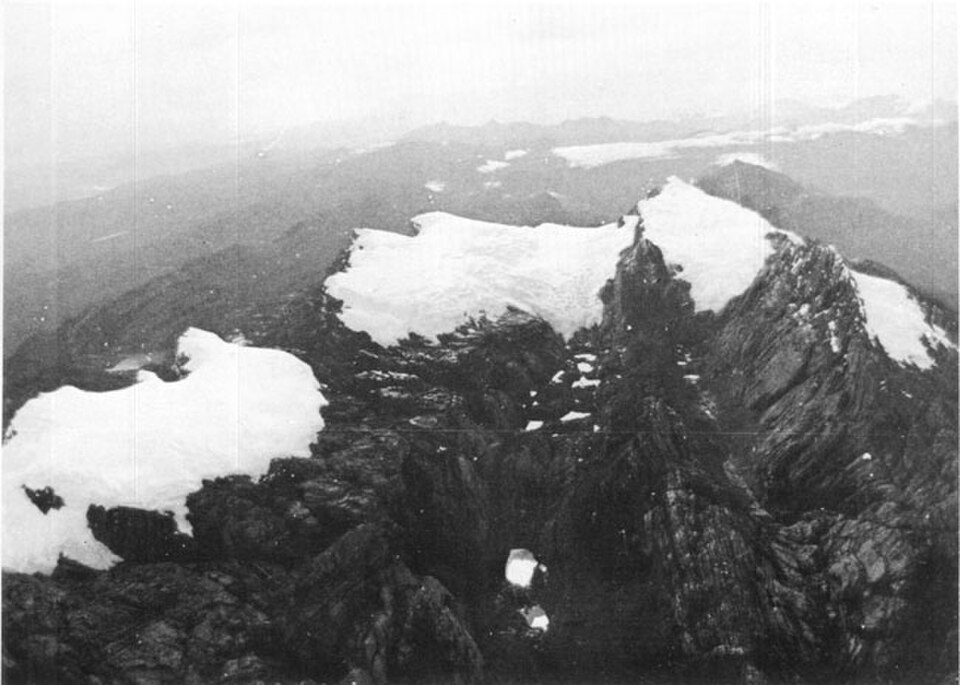
The photo at the top of this page is a 1972 oblique aerial photograph from the U.S. Geological Survey, taken during the Carstensz Glaciers Expeditions, according to its Wikimedia Commons file page. It looks east and shows, left to right, the Northwall Firn, Meren Glacier and Carstensz Glacier. The journal paper says the Meren Glacier vanished between 1997 and 20002.
Trivia
- Which island is home to the Sudirman Range and Puncak Jaya? New Guinea1.
- About how much ice area did Puncak Jaya hold in 1988, according to NASA's article? About 4.31 square kilometers (1.66 square miles)1.
- Which two Landsat sensors took the 1988 and 2026 images? The TM on Landsat 5 and the OLI on Landsat 91.
- What did the East Northwall Firn's thickness fall to by 2023, from 32 meters in 2010? 4 meters (13 feet)1.
- In what year does the 2025 Cryosphere paper say the glaciers are expected to disappear if the retreat rate persists? Around 20302.
Sources
- The Last Ice on Puncak Jaya, NASA Earth Observatory, Image of the Day, November 16, 2026. Accessed November 16, 2026.
- Ibel, D., Mölg, T. and Sommer, C., Brief communication: Tropical glaciers on Puncak Jaya (Irian Jaya/West Papua, Indonesia) close to extinction, The Cryosphere, December 8, 2025. Accessed November 16, 2026.
- File:Puncak Jaya icecap 1972.jpg, Wikimedia Commons file page. Accessed November 16, 2026.